|
|
Historical Background
Historical inscriptions show that Kodagu was included in the Kingdom
of Gangas in the 9th and 10th centuries and Cholas in the 11th century.
Changalvas were feudatory to both the above dynasties but they were independent
till 14th century since Hoysalas overthrew Cholas in the 12th century.
Changalvas accepted the supremacy Of Hoysalas from 14th to 16th century.
Then came the Nayakas who later paved the way to the Haleri Rajas of Kodagu.
The prominent rulers were Mudduraja (1633-87), Lingaraja (1775-80)
and Virarajendra Wodeyar (1789-1809). Kodagu was annexed by the British
in 1834, first Chief Commissioner's Province in India to be permitted to
have representative body in 1924, "C" State (1982-56) and a district of
Karnataka (Mysore) from 1st November, 1956.
According to purana Chandravarma the youngest son of King Siddhartha
of Matsya country came on pilgrimage to Brahmagiri the origin of river
Kaveri. He settled down with eleven sons married and each having more than
hundred sons. The eldest son Devakanta was crowned who with all the members
presented before Goddess Kaveri flowing down at Balamuri (Balumberi) in
the early hours of Tulasankranthi, the time of sun's entering the sigh
of Libra. During the flow the sari knot of Kaveri got turned backwards
at Balamuri while she blessed the
members present. All of them (Kodavas) took the first bath in the river
here.
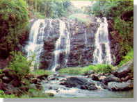
(abbi falls) ... |
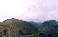 |
The country forms a portion of western ghats with the high range running
north-south along the western side of the district. The range has a bulging
towards west at Brahmagiri. The prominent peaks are Pushpagiri, Kote Betta,
Nishani Motte, Tumbe Male. Tadiandamol (1750 m, highest), Soma Male and
Brahmagiri
(Davasibetta) the birth place of Lakshmanathirtha river.
Payaswani and Bara Pole are the rivers
flowing west and Kaveri with tributaries Hemavati, Harangi and Lakshmanathirtha
are the rivers flowing east. High hill tops are generally grassy with valley
of dense mixed jungles and cardamom plantation. Low hill ranges are generally
under cultivation, teak plantation or dense mixed jungle. Elephant, tiger,
leopard, bison, deer, black wanderoo, hornbill, wild boar, peacock in jungles,
and mahseer, lady fish in rivers are worth mentioning.
Settlements
Jamma Land ownership under one family name as unit and right to own
gun with exemptions from Disarming Act since 1861 are the salient features
of settlement in a village. Families form a Keri, Keris a Village, Villages
a Nad and Nads a Taluk. There are 3 taluks forming the district viz.. Somvarpet,
Virajpet and Madikeri. Towns are generally formed by educational institutions
and public offices followed by business establishments. There is no railway
or air transport available in the district.
 |
 |
Economic Wealth
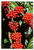
Coffee, cardamom, pepper. paddy, orange, timber and honey known as 'Coorg
Honey' are the major products of this district. Tea, rubber. Arecanut,
coconut, citrus fruits, pineapple, papaya, plantain, piggery and poultry
are also available from the district. There are no major industries in
Coorg, however there are considerable number of small scale industries
which produce bakery products, coffee processing machines, food processing
units, irrigation equipment etc.
 |
 |
Culture
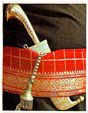
Kodavas follow Hinduism but are more liberal and independent than any
other Hindu in performing marriage, divorce, remarriage, festivals, worship,
ceremonies, dialect and dress. They worship Karana (ancestors) as family
deity, Kaveri as Godmother and Iggutappa as presiding deity. Most of the
temples in villages have their origin from Kerala and routine maintenance
is by Brahmins from Uttara/Dakshina Kannada districts.
Dowry system is unknown here and marriage ceremony with traditional
dress and without a Brahmin or puja or mangalasutra, but with non-vegetarian
dishes and liquor are unique of Kodava community.
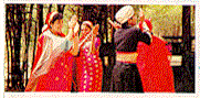
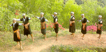
Puthari (Huttari) the harvest festival known for varieties of folk
dances 3 months after Onam in Kerala, Kailpoud the ayudhapuja with shooting
competition and sports on 3rd September and village temples with its own
set of discipline and dances during the annual fairs are the main centres
of cultural activities.
The Puranic version is upheld to this day with Annual fair at Balamuri
about 4 km from Murnad, every year in the morning succeeding Thirthodbhava
at Tala Kaveri, Kannipuje at home by ladies etc. Sari style of Kaveri with
the knot back at Balamuri is retained to this day by Kodava community.
 |
 |
Places of Interest
Kodagu has some of the most picturesque hill stations in south India,
When the British ruled India, Kodagu was dubbed as Scotland of India.
Western Ghats runs throughout the length and breadth of Kodagu and the
climate is pleasant throughout the year and the hills are ideal for coffee
plantations, Hence Kodagu is a coffee country and produces 90% of India's
coffee. Consolidated Coffee Limited, a Coorg based Coffee plantation company
is the largest coffee producer in Asia.
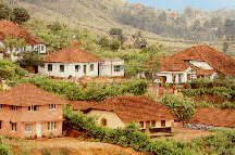
Madikeri
Madikeri is the district headquarters of Kodagu with about 28,729 population
and 1200 meters altitude. Muddurajakeri named after the first ruler Mudduraja
from this place since 1681 later became Madikeri. It is a picturesque hill
town with Palace inside Fort, Omkareshvar temple, Raja's tomb, Raja's seat,
Abbi falls, Cardamom Research Station at Appangala (7 km), Horticultural
farm which develops varieties of citrus, fruits at Chettalli (18 km), World
record holder in cardamom crop near Chettalli etc.
Gandhi Mantap : A mantap over the sacred asti of Mahatma Gandhi buitl in 1956 on the road leading to Raja's Seat. One can get a panoramic view of Bhramagiri range from here.
Madikeri Fort: In centre of Madikeri is the 18th century fort which once housed the royal family and the adminstration of the Kodagu kingdom. Today it houses a Ganesha temple (locally known as Kote Ganapathi), a Chapel, the prison and a small museum. A star attraction in the fort is a pair of a real size elephants made of concrete. One can walk along the walls of the fort and admire the miltary planning of the fort. One can see the structures built to house the cannons and gunners. There are tunnels which start in the fort and lead safely out of the city. These tunnels were built as an escape route if the fort is conquered by the enemy. One can see the entrance of these tunnels but you are not allowed inside as they are infested with snakes and scorpions.
Raja's Seat: A notable spot in Madikeri. Kings of Kodagu spent
their evening to watch the spectacular sunset. Also offers a thrilling
view of a flowing valley of lush feilds and towering Westren Ghats. Surrounding
the Raja's seat is a beautiful botanical garden.
Gadhige: Situated in the northen part of the town, are the four
tombs of Kings Veeraraja and Lingaraja along with Biddanda Bopu- the Warrier
and his son Biddanda Somaiah.
Omkershwara Temple: Built in 1820 by Lingaraja, It has a unique arechitecture for a temple for its a square building built in stlye of Mohemmedn edifice with a large dome in the centre and four minarets at corners, surrounded by basavas. On the top of the dome is a guilded ball with a weather cock. A large tank in front of the temple adds to the charm. The tank also has several large fishes which are one of the attractions of the temple.
Bhagamandala
Bhagamandala about 35 km from Madikeri has temples near the confluence
of river Kaveri with Kannike. Pilgrims perform rituals during Tulasankranthi
(October). This is the center for bee-keeping.
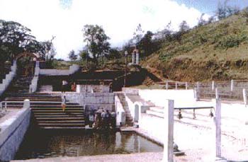
Tala Kaveri
This is the origin of river Kaveri on the eastern slopes of Brahmagiri
peak at 1350 metres altitude, about 8 km by road from Bhagamandala. An
enclosure around the spring called Gundige is connected to a small pond
beside. The water from the pond goes underground and comes out after about
one kilometer down the hill. There are three shrines above the spring and
birds eye view of west-coast from the hill range. On a predetermined date
and time of Tulasankranthi every year the spring from Gundige overflows
called Thirthodbhava. This holy water is carried home by all pilgrims when
they go back after paying the last rites/rituals to their parent or spouse
departed during the preceding year. New couples will also have a dip in
the pond together.
Padi Iggutappa Temple
This is the most important temple of Kodagu and the presiding deity
for Puthari festival. It is about 2 km by road from Kakkabe. Nalnad Aramane
(Palace) built in 1791 is about 5 km from Kakkabe. Hiking to the highest
peak Tadiandamol is through Nalnad Aramane. Largest producer of honey in
South East Asia is about 4 km from Kakkabe.
Nalknad Aramane
Built by Doddaveeraraja in 1792, Situated close to Tadiandamol,
the highest peak of Kodagu (5724ft). It is beautiful two story building,
with beautiful wooden carvings. At present it is a bee keeping center.
Irpu falls
Irpu falls 60 meters of Lakshmanthirtha river is about 45 km from Virajpet.
There is an ancient temple dedicated to Lord Shiva by Sri Rama himself
on the right bank of Lakshmanthirtha river. There is a big congregation
on Mahashivaratri day.
Nagarhole
The Nagarhole Game Sanctuary extending over 284 sq. km affords an excitable
sight with wild animals like bison. tiger, panther, elephant etc.in their
natural habitat. There is a guest house and a restaurant. There is an elephant
training camp near Titimati.
Others
Other tourist spots near Kushalnagar are:- Kudige with agricultural
and dairy farm, 6 km; Ramaswami Kanive with aqueducts across river Kaveri
9 km; Harangi Dam; 10 km, and Nisargadhama a tourist resort on river Kaveri,
3 km. Honnammana Kere is a lake about 10 km from Somvarpet.
If have any more information, send me an email at  ...........................................................